Sunday, 26 October 2014

How to cook kangaroo tail

How to cook kangaroo tail

This will probably be my shortest post ever, as it's pretty simple.

Where's my tail?

Out in the bush (i.e, west of the Divide), supermarkets often sell kangaroo tail. Big monsters of things, they're usually in the freezer section and are like a massive hairy club. They don't seem to make it to the city (certainly, I've never seen them), and I reckon it's because people in the bush know they're onto a good thing. Most kangaroo meat is very lean (so quite healthy for a red meat), but the tail is one of the few places that has a fair bit of fat, adding succulence and a rich flavour. Several times I've heard Aboriginal people describe it as "a meal in itself". It's messy and very tactile to eat, like chowing down on a crab (you'll need a good wash afterwards), but good fun and dead easy to cook on a campfire.

Method

First, take your tail (defrosted) and burn the hair off. This involves either chucking it on a fire for a minute or two, or somehow holding it over a fire and singeing it until black all over.
Then wrap it in alfoil. Wrap it well - one layer probably isn't enough. If you've cut the tail into sections, it'll look like a few garlic breads, or otherwise it'll be one lovely big silver present.

Then put it on the coals of the fire. Heap other coals over it.

After about 40 minutes, it should be done. I was recently told one of the best ways to check it is to stand on it, and if it is a bit squishy, it is done. If still hard, then put it back on. You can also try opening up a bit and seeing if the meat is cooked.

Then, let it cool a little (that fat will be quite hot) before attempting to wrestle with your meal.

Bon appetite.

Sunday, 19 October 2014

Aileron Roadhouse

Aileron Roadhouse

A bit over an hour north of Alice, this dusty truckstop is about to have a makeover. Of sorts. Well, some grass, anyway.


Big Man Walk, Aileron Roadhouse

Picture Alice Springs on a map of Australia. If you're as geographically challenged as I didn't think I was, you'll probably put it much further south than it is. Even though I've been there several times before, I honestly hadn't realised how far north it is until I drove up the Stuart Highway. It's only about half an hour out of Alice that you cross the Tropic of Capricorn. Yes, that tropic – the line that runs through Rockhampton and cuts the west coast between Exmouth and Carnarvon.
Another 40 minutes or so up the road and you come to Aileron Roadhouse. In many ways it's barely distinguishable from any of the other roadhouses up this way – a dusty area to park your van or tent, a few rooms to rent, a bar (of course – this is the NT afterall), a general store, and some standard pub fare. Actually, the food is better than most (the roast chicken was a huge feast and quite delicious) and the rooms aren't bad, although mine needed some serious airing when I got there (it stank).
Big Blackfella, Aileron Roadhouse

But it has an incredible 17m high statue of an Anmatjere man, holding his spear, at the top of a hill behind the roadhouse. Costing about $120,000, the statue was built by Mark Egan and erected in 2005. There's a short little climb up the hill at the back (a leisurely 20 minutes return), which is worth it because it offers a great view over the surrounding plain. You'll also find out how big the AILERON letters are near the Big Blackfella, and see how impressive a figure he is.
In 2008, Mark added a huge woman and child, hunting goanna, down beside the roadhouse.
Woman and child hunting goanna

A working cattle station, Aileron has a couple of other great features that you can explore. From the top of the hill you can look over the old racetrack, built 1940s, or explore it via the bush tracks. It's still used for the Aileron Bush Weekend, held 4-5 April next year, which includes a rodeo. And if you haven't been to a bush rodeo yet, make sure you put it on your bucket list, as they are extraordinary spectacles.
Strangely, I felt like a run, so went out to the track and ran a few miles. I didn't whinny though.
Two other things happened during my brief overnight stay there earlier this month: the owner revealed that Aileron is getting a more secure water supply, which means they will endeavour to grow some grass to keep the dust down and some more plants to pretty the place up a little (although they've been warned by regulars not to change it too much); and photographer Heath Holden and I were lucky to witness the full lunar eclipse in those clear skies.
Blood moon and the Southern Cross, from Aileron Roadhouse

Through our camera lenses we played with the blood-orange moon and a windmill for a while, then walked up the hill and experimented with the statue looking at the eclipse. All good fun, but the best bit was putting away the cameras up that hill, pulling out a couple of cold XXXX, and just watching the eclipse beside the Big Blackfella, from his vantage point watching over the whole region.
Ahhh. That's NT bliss.


Sunday, 12 October 2014

Camping at Devils Marbles

Camping at Devils Marbles (Karlu Karlu)

Not the best camp ground in the world, but the sunset and sunrise makes it worth sleeping at this magic spot.


Devils Marbles, just off the Stuart Highway, Northern Territory.

It's no wonder that brilliant Aussie landscape photographer Ken Duncan only refers to this classic  landmark as "God's Marbles". Pretty much in the middle of the Northern Territory, the marbles are a spectacular sight and combine so much of what we photographers love about our arid regions: brilliant red rock that gets redder at sunset and sunrise, a fairly harsh, flat landscape around it, and fantastic geometric shapes that are a photographer's dream.
It has a few Indigenous names, but the most commonly sprouted is Karlu Karlu. For a few years many of us were told that to the "Aboriginal people" (not sure which group) these large 1.6 billion-year-old granite formations were the Rainbow Serpent's eggs. No one I spoke to seems to know where this idea came from, and the Alyawarre people I interviewed recently referred to instead a vast Dreaming figure who wore a hair belt. The hair belt became dirty, and as he spun around, bits of mud and hair came flying off the belt to form Karlu Karlu.
Sunrise, Karlu Karlu

To the casual visitor, the site is "in the middle of nowhere". It's a decent drive of four hours from Alice, and an hour from Tennant Creek, so many people who are passing through tend to go there in the middle of the day. It's pretty much the worst time to be there. It's undoubtedly hot (with little shade anywhere) and the boulders themselves are at their colourless worst.
If you want to see them early morning and late evening, you can either stay at the Wauchope Hotel about 15 minutes drive down the road (nothing to rave about, but clean sheets and a telly), or you can camp.
Under an almost full moon

The campground is right at the Devils Marbles. I slept in a swag, and with an almost full moon, had a glorious, ever-changing view of the features all night. Great for star-trail photography etc, and just being in such a wonderful place. It's no effort to get up for sunrise and you don't need to drive anywhere - you can just pop out of bed and you are right in the area. There's plenty of opportunity then to walk around the huge area and look at many of the features as the sun plays its golden light over the surfaces, and the shadows gradually change.
The campground, however, has no water and very little shade. There are probably two campsites that have a decent tree, but the other 20 or so don't - so either get there early and grab the good sites, or expect to have no shade! Once again, there's no water (and if you are there during the middle of the day, you'll need some), but there are pit toilets. The one furthest away from the campsites (only about 100m away) is not surprisingly the least smelly.
There are little fireplaces at most of the campsites, but you'll need to bring your own firewood.
Overall, it was a pleasure to finally get to this spot of which I've seen so many photos  (and now have so many photos of my own). I'm really glad I camped there, to hang around for the sunset and sunrise, and fully recommend sleeping in a swag, which you can set up with your own personal view of the marbles, in the hotel of a thousand stars.
Sunset, Karlu Karlu


www.kensbigbackyard.com.au  

Saturday, 6 September 2014

Top 5 Spring Walks in NSW

Top 5 Spring Walks in NSW

Season of snakes and small birds, spring in the NSW bush is rarely as spectacular as it can be in other parts of the world, but in some areas the bush tracks are festooned with flowers, and the amiable weather can suit short strolls or longer treks. It's a great time to be in the outdoors.

Here are five of my top recommendations for spring walking in this diverse state.

Waratahs aplenty near Pulpit Rock, Blue Mountains.

 1. Evans Lookout to Pulpit Rock, Blue Mountains
Virtually one continuous lookout along a spectacular clifftop, this 13km return walk provides stunning views of waterfalls, valleys, cliffs and one of the best opportunities to see NSW waratahs on a main track in the Blue Mountains. It undulates a little, but there are no large descents or ascents. The ending, Pulpit Rock, is surely one of the most underrated, dramatic features in the mountains. Access the walk via Evans Lookout Rd, Govetts Leap Rd or Pulpit Rock Rd.
The dramatic Pulpit Rock lookout.

2. Muogamarra Nature Reserve, Sydney
Usually only open for six weekends a year in spring, this wonderful refuge north of Hornsby has wildflowers galore (including NSW waratahs), Aboriginal engravings, lookouts and historic features. I've written a whole separate blog on this wonderful spot, which you can read here. If you're looking for something to do on a weekend in spring, I thoroughly recommend it.

3. Grand High Tops, Warrumbungles

Warrumbungle National Park. Amazing wildflowers in a dramatic volcanic landscape.
One of the most classic walks in NSW, through impressive volcanic country, this 16.5km loop walk was closed for some time after the devastatingly destructive fire of January 2013, but has recently reopened. Although the bush will take a long time to recover, there will be wildflowers out during the spring, and the views of features such as The Breadknife, Belougery Sprie, Crater Bluff and Bluff Mountains are some of the best in the state at any time of year.

4. Boomeri Camping Area to Shelley Beach Camping Area, Myall Lake

Best done as an overnight walk, this 25km return walk does involve a lot of slogging along a flat fire trail. But if you keep your eyes open, it will be a spring wonderland of wildflowers and wildlife, with birds galore, goannas, lizards, snakes and other surprises. The camping areas at Johnsons Beach and Shelley Beach are delightful, and worth hiking in for. Both on the shores of Myall Lake.

5. Light to Light Walk, Ben Boyd National Park

Ben Boyd National Park

I still believe this is the most spectacular coastline in NSW. It is right in the far south-east corner of the state, and this multi-day walk (probably best over 2 days) goes between two lighthouses, one of which you can stay in. The colours are extraordinary, from the orange and maroon rocks, to the turquoise and aqua water, and the wildlife is rich, with turtles, whales, wallabies, wombats and dolphins. It is relatively flat, easy walking, and there is a great camping area halfway, at Saltwater Creek. The worst thing is that the 32km walk currently has no organised transport to get back to the start, so you either need to do a long, long car shuffle, or walk both ways. Or you could just drive to Saltwater Creek, set up camp, and go for long day walks in each direction.

Full track notes and more information is provided on all these walks in my book, Top Walks in NSW. It's currently available for a bargain if you look around, and there's an e-version to download on your ipad.

See you on the track
www.kensbigbackyard.com.au

Sunday, 24 August 2014

Latest Glam Multi-day Walks in Australia

Latest Glam Multi-day Walks in Australia

Comparing two of the latest guided multi-day walking experiences in Australia 

Scenic Rim Trail, southern Queensland

Looking for something more than a day walk, but not sure you want the hassles of carrying a large pack and tent? Want to finish a day's walk with a hot shower, comfy bed and a glass of wine, not a packet of two-minute noodles and a thin mattress on the ground?
Great Walks of Australia has a growing list of Australia's best multi-day walking experiences, but with strict criteria to get on their list: there must be private accommodation along the way, an emphasis on quality food and wine, and walks must be guided by knowledgeable guides.
I've walked parts of nearly all the walks listed by Great Walks of Australia, and this year, through my work for various publications, I was blessed to enjoy two of the latest walking experiences on offer in the great walks group. Here's a little compare and contrast, in case you were considering either. Please note both trips were provided gratis to me.

Scenic Rim Trail
This is the newest and cheapest of the Great Walks of Australia - but don't be fooled into thinking this is a shonky operation. Established by the classy Spicer's brand, the highlight here is definitely the food and the accommodation. Much of the walk is on the company's own beef farm in south-east Queensland, wandering through forests, woodlands and up mountains, occasionally dipping into national park. There are some great views to be had, and some lovely ancient hoop pine forest. It's pleasant, but for the most part, the walking isn't what you'd call spectacular. It's at the other end of the Scenic Rim to the renowned Lamington National Park, which for my money offers more beautiful terrain in this part of the country.
The mid-year season means that the weather on this three-night trip will almost always be pleasant too, with cool, crisp mornings (surprisingly cool for Queensland because of the relatively high altitude) and dry and warm days. The walking days are not too strenuous, although the uphill hikes will certainly make you feel like you are justified in having an extra glass or three of something at the end of the day. You don't have to carry any gear, apart from a camera, water and lunch, so the walking is wonderfully free and invigorating.
View from my plush bed at sunrise at Spicers Canopy.

The first two nights of the experience are spent at the exclusive Spicers Canopy glamping tents. These large, safari-tents have huge comfy beds in them, lounges and luxurious bath robes. You can leave the canopy doors wide open and watch the stars from the comfort of your huge bed, or seal everything up. Food and wine are divine, and only superseded by the final night, when you stay at the luxurious five-star Spicer's Peak Lodge, the highest lodge in Queensland, and are treated to a sumptuous seven-course degustation dinner, with matching wines. It's an extraordinary way to finish the trip, and certainly worth walking up a couple of mountains.
Spicers Peak Lodge. Ahhh.


Overland Track – in winter!
Since 1987, Cradle Mountain Huts has been guiding people 65km along the iconic Overland Track in the Central Highlands of Tasmania, past the craggy shape of Cradle Mountain, over passes and through sodden valleys all the way to Lake St Clair. It can be super wet, super cold, super muddy and some people have done the whole trip without ever seeing a mountain because they were shrouded in thick mist and rain the whole time.
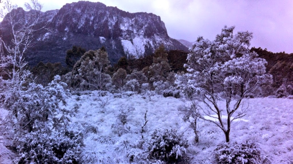
View from Cradle Mountain Hut of Cathedral Mountain after heavy snowfall.

For the first time ever, Cradle Mountain Huts decided to trial a winter experience this year. Allowing an extra night (so now six nights), it wanted to see if guests were keen to see this gorgeous part of the world when it is at its coldest. And stunning it was. The rivers were thundering, the snow was thick and soft and deep in places, and the forests with snow in them were a fairy land. I can't show you many photos, because my story in OUTBACK magazine is still to come out (keep an eye out for the Oct/Nov issue), but sufficient to say it is probably the most beautiful long-distance bushwalk I have ever been on. We had wind that knocked us over, rain that soaked us, and snow that filled our packs, but it was worth it.
Top of Pelion East in winter.

This is not a walk for non-walkers. Some days were taxing, and because there is no other access to the huts, you need to carry a reasonable load (at least 15kg), including snow shoes, crampons and emergency sleeping gear. But at the end of each day, you get to the secluded and private Cradle Mountains Hut, to have hot showers, a glass or two of wine, and a delicious and nutritious hot meal cooked by your guides. There is certainly no degustation menu, but the food is plentiful and surprisingly good, with three or four courses every night. The huts are welcoming, but it is not five-star. The bedrooms were iceboxes, and you need the warm sleeping bags provided.

Overall, the experiences couldn't really be more different: one is perfect for casual walkers who want a different experience and to enjoy some top-class food and accommodation; the other is an incredible walking experience, with the comfort and safety of guides and huts, but in the wilds of a Tasmanian winter and whatever it decides to dish out.
Or to put it another way, one is perfect for my wife, the other perfect for me.

See you on the track
www.kensbigbackyard.com.au

Saturday, 2 August 2014

How outdoor shops are stopping people going outdoors

Outdoor shops stopping people going outdoors

Our capitalistic, narcissistic obsession with "stuff" is making it too expensive and too damn hard to go bush.

An amazing camping experience, without all the latest "essential" gear: North West Island, Queensland.


Back in the Middle Ages, when I was studying at the University of Technology, Sydney, advertising 101 included the basic aim of advertising in a capitalist economy: to sell people stuff they don't need. It's pretty simple really – if people actually need things, they either have them already, or know how and where to get them (and are simply prevented by circumstances such as finances). So advertising's only purpose is to convince people that they actually need more than they currently have, in order that they will buy stuff and keep this strange, environment-destroying economy going. Economic growth is purported to be the ultimate good, and the sign of a "strong" politically adept society, as opposed to a malfunctioning catastrophe that is continuing to plunder resources to create things we don't actually need.
Been to an outdoor/camping shop lately? Seen the extraordinary range of goods on offer? I'm talking about Kathmandu, Mountain Designs, Paddy Pallin, etc, etc. The range is bewildering at best, and the prices, in many cases, extraordinary.
My elder sister (now the high side of 50) received a Duke of Edinburgh award when she was at school. She had a simple, two-pole A-frame hike tent that I was still using 20 years later, a fairly crappy, heavy sleeping bag, and a rough, framed pack. My folks weren't rich, but could afford all of that, and encouraged her to go, despite her tiny size and lack of experience.
Today, I hear of parents not allowing their kids to do the excellent Duke of Edinburgh program, because it simply costs too much. By the time the kids buy all the gear, and pay for the increasingly heinous and compulsory costs for the school to employ an outside company to run the program (in most cases now, it's not considered acceptable for a teacher with great camping/hiking experience to run the course), the cost can be well over $1000. This is just for kids to get out in the bush and go for a walk for a couple of days. I think it is obscene.
My encouragement in my book, Top Walks in NSW, and in fact whenever I get the chance, is to just get out in the bush with a few simple things, and down the track work out if you'd like to upgrade something.
Start simple, and add things as you feel you need them.

If you are not doing something extreme (such as off-track camping in the high country in winter), and take a few simple precautions, you really don't need a lot of "stuff" and you don't need to spend hideous amounts of money, despite what the outdoor shops will tell you. Yes, you need something on your feet. If the track you're planning isn't particularly stony, try your sneakers if you have nothing better. Heck, the old Dunlop Volleys was used to set some of the most classic rock climbs in the Blue Mountains.
Yes, you need a pack to carry stuff in, but I wouldn't recommend spending hundreds of dollars until you know what you want. My wife just bought a $40, 65-litre pack from Aldi for my son. I loaded it up with some heavy weights and took it for a field test . It has pockets in the right places, a rain cover, padded hip straps, and certainly on a three-hour walk was as comfy as my $250 pack. I don't expect it to last as long, or to be as good in all conditions, but heck, maybe that's all you need. And why spend $250 or more on a pack if you use it once every two years?
A $40, 65-litre Aldi backpack. No worries.

You will need a raincoat, but I find little difference between $70 raincoats and $300 raincoats. I get slightly damp (but not wet) in both. You will need something to cook on, and something to sleep in, but you may not need to get the most recent ultra-light, Himalayan standard sleeping bag if you are just going car camping a couple of times a year. In fact, if that's the case you may not even need a bag at all - often a doona and sheets will be more comfortable anyway.
Some of the staff in outdoor stores are incredibly knowledgeable and keen hikers/climbers/canyoners/campers themselves. Their advice can be invaluable. But just don't get sucked in to thinking that you need the latest and greatest thing in order to get out in the bush. You don't.
I'm about to hit the Overland Track mid-winter, during a predicted fierce cold snap, with snow down to 200m. I'll be interested to see how my conglomeration of assorted gear from various previous outdoor sports over the years (skiing, canyoning, hiking etc) stands up to the challenge. The only thing I bought new was $40 gaiters, as I've never previously had the need to buy them, although I did once borrow a friend's pair of gaiters for hiking through spinifex in the Kimberley.

Hope to see you out there sometime.
www.kensbigbackyard.com.au

Saturday, 19 July 2014

Red Hands Cave walk

Red Hands Cave walk

One of the closest Blue Mountains walks to Sydney is a cultural spectacle through a bird-filled valley.

Red Hands Cave, showing hand prints and hand stencils in different ochres.

I've mentioned before that one of the difficulties for those of us who bushwalk regularly is that we have  favourite walks and favourite areas to walk, and it can become hard to make the time to try other areas. When I do get a half or full day to go hiking, I want to go somewhere that I know I'll love, rather than just somewhere ho-hum.
As a result, when I'm driving up the Blue Mountains from Sydney, I nearly always drive past the Glenbrook entrance to Blue Mountains National Park, which holds just about the closest Blue Mountains walks to Sydney. In fact on a Sunday morn, it's less than an hour's drive from my place in suburban Ryde. You basically drive up the steep escarpment and Glenbrook is the first little village. The only times I've really hung around this area are because it's the end of the legendary Oaks Fire Trail mountain bike ride, or because of the extensive camping and picnicking areas at Euroka Clearing, where wallabies and kangaroos are fairly easily spotted at dusk.
Many times I've driven past, knowing that a walk I would do "one day" would be the little walk to Red Hands Cave, an Aboriginal site. I've seen lots of handprints and hand stencils on walls before, so I guess it hasn't been high on my priority list.
But today I finally got there, and it's a little gem of a walk. If you start down at the delightful Jellybean Pool (perfect for a swim in summer) it's basically a P shape walk, with a loop at the far end. It weighs in at about 8km, and 11-year-old legs today did it in an easygoing 3 hours, with a few breaks.

Start

You can park at the top ranger station, or I think it's better to drive to the Jellybean Pool carpark (in summer this might be crowded). Wander down the stairs to the pool, then turn sharply right and scramble up and over track along the creek to the right. After about 5 minutes, you'll hit the road. Cross the causeway, then turn right along the marked track.
Across the causeway, Blue Mountains National Park, Glenbrook.

This takes you up a lovely bird-filled valley. Without trying, we saw whipbirds, gang-gang cockatoos, king parrots, golden whistlers and fairy wrens. There are some lovely large overhangs to check out and some gorgeous mixed trees in the forest, including the pink smooth-barked apples. A bit over half an hour of walking will bring you to the loop track.
Red Hands Cave Walking Track.

Red Hands Cave

I think the loop is best done anti-clockwise (because of the steep stairs on the loop track), so continue straight ahead, and the walk gradually climbs up the valley. Then all of a sudden you'll be at the sensational Red Hands Cave. Unlike many sites, it has both hand stencils (outlines of hands) and hand prints, and the dozens of images are starkly clear. It of course has a large mesh barrier around it, but even that doesn't take away from the magnificence of this site. Handprints have been estimated at up to 1600 years old, and there are a few other drawings too. On the floor of the cave you can clearly see the ochre grinding grooves, some stone tools, and a pile of red ochre.

The loop 

Once you've enjoyed this special spot, continue up the path, and in about 10 minutes you'll hit the car park and picnic area, which has a pit toilet. A track leads from the picnic area (not marked), which is the loop track. It seemingly heads off in the wrong direction for a while, but does make it back, via a different, lovely valley. Half an hour's walk down this track will take you to a small rock clearing on the creek on the left hand side. Stop here, as it has some very well defined and picturesque axe-grinding grooves. Stay for a while and see what else you notice, as there are other less-defined features. It's a good spot for a break.
Clearly defined grinding grooves and other features.

Back for a swim

The main track continues about another 5-10 minutes before it rejoins the original track, and you simply turn right, and follow it back to Jellybean Pool and that waiting swim. It's pretty brisk in winter, so you can almost guarantee you'll have it to yourself.
Overall, it's a corker of a little walk, and I really felt privileged to see two such well-preserved Indigenous sites so close to Sydney.
www.kensbigbackyard.com.au