Tuesday, 6 October 2015

Cave Climb

Cave Climb

A classic, great fun multipitch climb off Narrowneck, in the Blue Mountains, Katoomba.

What a route! Cave Climb, grade 13, trad.

For as long as I can remember I've adored the Blue Mountains. This World Heritage Listed area on Sydney's backdoor step has always been my outdoor playground. From family bushwalks from the time I could walk, camping trips, Christian camps in my teens, right through to modern adventures mountain biking, canyoning, hiking and rock-climbing, its wonders never cease. There are pockets of rainforest, splendrous sites such as Blue Gum Forest and those gorgeous orange and grey sandstone cliffs that beckon those of us that like getting off the ground.
There is just SO MUCH ROCK! I can spend hours just flicking through the Blue Mountains Climbing guide book finding great routes that I want to do, knowing full well that I'll never have time to do even a quarter of the routes that I am capable of doing, let alone all the harder ones that are out of my league.
One climb that had been recommended to me a year ago was Cave Climb, off Narrowneck. It's a grade 13 trad climb, meaning it's relatively easy and fun, but you'll need a full rack of gear and know how to place it. I've been a climber for considerably more than a decade and have climbed trad and sport routes across Australia (including Mt Arapiles), but I only bought my first decent trad rack a year ago, and – after an excellent day of advanced tuition in placing trad gear – was recommended a few great Blue Mountains routes to go and practice my skills.
First climbed in 1962, this brilliant adventure route isn't done a whole heap, because most contemporary climbers just seem to want to stick to steep, bolted routes that are within a short drive of a good coffee shop. The idea of actually having to place your own protection into cracks in the rock certainly isn't for everyone, particularly when you start getting a long way off the ground or have to carry all that gear a long way. But there are just so many beautiful, big, bold routes that those old timers did – with little more than a rope tied around their tummies – and I'm looking forward to crossing a few more off over the next decade or so.

Access

Spectacular view from the anchors
View down the cliff.


It's a 5 minute walk in through some scrub and then a 40m abseil off reasonable anchors. The guidebook refers to a national park sign, but as far as I can tell that doesn't exist at the moment.
Drive along Glenraphael Drive (dirt road going out along Narrowneck) for 1.4km and park in a little turnout on the right hand side. Walk carefully up the road watching on the right hand side and 20–30 metres later you'll see a small cairn and scrubby track heading off to the right. It heads down and to the right, then you scramble down a gully and past a great little bivvy cave. Follow the track down to the cliff edge and on the left you should see the two anchor chains. They are pretty exposed and there is a ring bolt about 5 m back to belay/safely rappel down to the chains. Our ropes got slightly caught up in shrubs after we threw them off, so best to send someone down first who can sort that out if necessary.
About halfway down you'll see the entrance to the cave that the climb is named after.
For another description of finding the anchors, see https://huckanddyno.wordpress.com/2013/06/11/finding-the-cave-climb-rap-point-at-narrowneck.

Start

Cave Climb Direct Start. The original start is to the left.

The initials clearly marking "CC-DS" (Cave climb direct start) are right at the base of the abseil. The original start is a few metres to the left. We did the direct start, with a little tricky first move (a high step) to get off the ground. There are a couple of carrot bolts within the first 5 metres, but you'll need to place some other gear.
In the guide book, it's listed as a three-pitch climb, but it seems logical when climbing to run the first two pitches together, and aim for the entrance of the cave. A combination of following the corner crack and occasionally veering out onto the wall on the right will get you up there. The moves are enjoyable and the rock solid.
BIG TIP: take a lot of big pro. I really wanted a couple more big hexes and a number 4 or 5 camelot. Higher up I found a few places for smaller gear, but the first half of the pitch really requires a fair bit of big gear, and when you get to the cave it would be nice to have some big pieces to back up the two bolts at the belay station.

The cave
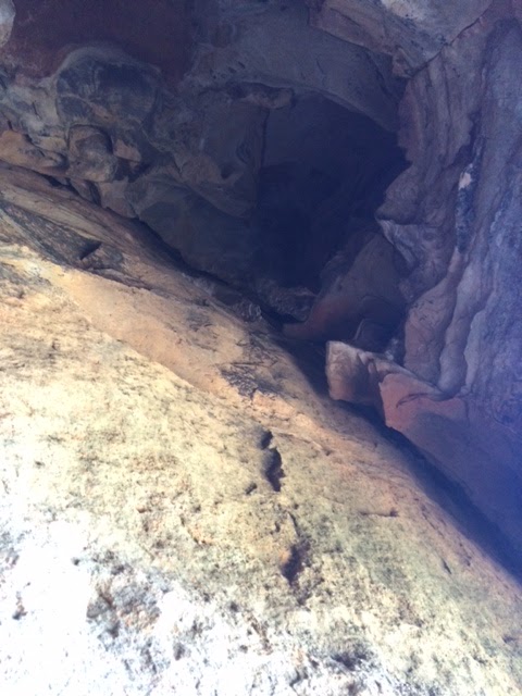
View straight up, into the cave. Note jugs on right
View straight out, looking out of the cave.


Sitting on the ledge at the belay station, the view directly above is of a dark cave about 5 metres high. Somewhere up there to the right is the cave exit. It's a pretty dicey and technical lead through the cave, and some parties may take the easier option of continuing the climb outside the cave, rather than going through it. The trick we found was to head up a few metres to the left, place some big gear with long slings, then traverse across a reasonable foot ledge (with two fairly small handholds) to the big jugs high on the right side, and then out the hole back into the sunshine. It's a great fun start to the pitch if you're up to it. I was thankful for a partner who reminded me to just keep really good stances and stay calm while I was placing the gear, as a fall would be awkward at that point.
View from the top of the cave looking down.

The problem

High wind seems to be common on the last bit of the pitch up to the top. It makes it exhilarating and fun, but also means when you get to the top you can't hear your partner, or see them (because they are in the cave). So you'll need to have your rope tug signals worked out. To make matters worse on our climb, the rope jammed in a crack, so I thought I had my second tightly on belay, but they basically had to climb the cave with loose rope until the jam freed.
The belay at the top however is quite good – there are two carrot bolts a couple of metres to the right of the anchor chains, and a couple of good ledges and cracks to back them up with.
An alternate ending that isn't in the guide book seems to be a more vertical route to the left. It has ring bolts and looks quite entertaining.

Overall, this was a fantastic morning out, with brilliant views, great rock and some interesting pitches. I was pretty slow and careful on lead and it took us about 2.5 hours car to car, but I would imagine more experienced trad climbers would do it in half that time.

For a good laugh at another's experience on this climb, read Huck and Dynos hilarious account https://huckanddyno.wordpress.com/2013/03/22/cave-climb.


Tuesday, 16 June 2015

Tassie's tourism secret

Tassie's tourism secret

What is the problem that Tasmanian Tourism authorities talk about in hushed tones and candid off-the-record statements?

The summit of Mt Wellington, Tas. Too boring for some?

On a recent visit to Hobart I overheard a comment that I've heard several times before from people in the Tasmanian tourism industry.
"There's nothing to do in Hobart".
Bear in mind that this is usually expressed by people who love both Tassie and tourism, but are searching for ways to increase the length of time (and amount of money) people spend in Hobart. Usually the comment is accompanied by "apart from the bushwalkers". Bushwalkers, it seems, get out of Hobart's CBD pretty quick, and find plenty of ways to enjoy what is truly one of our most consistently beautiful parts of the country. Everytime I go to Tassie I am blown away anew by its devastatingly handsome features – its lush gorges, rainforests, sodden wind-swept plains, remote beaches and icy peaks. But I am a bushwalker, so perhaps I'm not the sort of person who needs to be convinced.
Admittedly Hobart, and perhaps all of Tassie, is a place that you can go to in order to slow down a bit and breathe again. It doesn't have crazy theme parks or traffic jams outside major attractions. And that's a bloody good thing, I think.
However, for those who are looking for "something to do" in Hobart though, I thought I'd give a few ideas, based on this latest and other trips.

1. Whisky tasting

Tasting at Larks Distillery.

Tassie's single-malt whiskies are now declared the best in the world. Yes, we are beating the Scots at their own game. I used to detest whisky (thinking it tasted like petrol) until I was convinced to try a single malt scotch. Suddenly I understood what the fuss was about. Apart from all the great pubs around Hobart's wharf area, there is a brilliant place to start developing your appreciation of whisky, at the Larks Distillery cellar door, bar and tasting area. Pick up a tasting palette, consisting of four half nips, for $25 and sip carefully, and you'll notice the subtle differences.

2. Go kayaking

You can either do a gentle 2.5-hour paddle around the Hobart waterfront, including a fish-and-chip meal served in your kayak, or if you're after more adventure, go on a full-day kayaking tour to the Tasman Peninsula with Roaring 40s Kayaking. Either way, a great experience on the water.

3. Eat fresh local produce to your stomach's content

I was reminded on this latest trip just how good Tassie's fresh produce is - particularly the seafood. Pick up a whole bunch of fresh fruit and veggies, or special foodstuffs such as mead or a Tasmanian scallop pie, at Salamanca Market on a Saturday morn. Then work out which of the many excellent restaurants, pubs or cafes you want to dine in. I can definitely recommend Mezethes Greek Tavern in Salamanca Place, and, slightly out of the main city area, towards the casino, The Royal Yacht Club of Tasmania, which was surprisingly inexpensive for somewhere with great water views, good food, and a little fire.

4. MONA

Inside MONA, including giant work by Sidney Nolan, Snake.

Yes, the museum of sex and death as it is known is well known worldwide now as a "must-do" in Hobart and . The art is confrontational, objectionable and incredibly clever, and the extraordinary underground gallery is like a dark maze where you just randomly almost bump into various art works. Take a boat from the wharf area, rather than driving there - the fare is worth the relaxing trip up and down the Derwent.
The Derwent River

5. Go for a walk

I know, we were looking for alternatives to walking, but it really is a great town to wander around. The wharf area is particularly interesting, and you'll find a few treasures along there, such as the new(ish) Mawson's Huts Replica Museum, which is only $12 to enter and is right next door to Larks Distillery, as well as other little art galleries and museums. The Botanical Gardens are particularly beautiful, and you can extend a walk there by tromping through the vast Domain area. Or take the drive part way, or all the way, up the winding road on Mt Wellington. In the winter months you're almost guaranteed to find some snow and freezing conditions. There's an amazing network of trails with walks to explore many of the mountains natural treasures, rather than just doing what most people do (which is spending about 10 minutes at the top looking at the incredible view, then driving down again).

And of course, if you have a car and start heading a bit out of town, well... there's a whole gorgeous state out there to enjoy...
See you on the track.
www.kensbigbackyard.com.au

Sunday, 3 May 2015

"Tops" destination for the outdoor family

Tops destination for the outdoor family

Canoeing on the Barrington River, near Gloucester, NSW

You'd think a beautiful World Heritage Area only a couple of hours drive out of Sydney would be hugely popular. But Barrington Tops and the area around Gloucester, NSW, is one of our state's forgotten treasures. For outdoor-loving families, it's a no-brainer. Get up there - any season!

The area holds some of the southernmost parts of the vast Gondwana Forests World Heritage Area, and some glorious subalpine areas where it snows. At any time of the year here a drive up into the mountains is likely to see temperatures about 10 degrees colder than in Gloucester. 

At Christmas and Easter camping is popular along the rivers and in the national park. There are plenty of places to camp, including the popular Camp Cobark, which offers horse riding. But if you want somewhere guaranteed to be dry to come home to, and a few more creature comforts than camping usually offers, then I'd recommend Barrington River Hideaway. The website is a little deceptive, and there isn't really much of a hands-on "farm stay" element, but the four 2-bedroom self-contained cottages are in a lovely quiet spot over the Barrington River where you can paddle and swim. There's also a lovely communal campfire area, myriad frogs, and lovely decks on which to enjoy the birdlife.

Activities

Canoeing

Canoeing on the Barrington River, near Barrington, NSW

Most people who holiday in the area seem to have a kayak or canoe of some sort, and shooting the fun, but rarely scary rapids is a common activity. Access points on the Barrington River include Rocky Crossing, Bindera and the junction with Cobark River.
If you don't own any of your own gear, fear not, Barrington Outdoor Adventure Centre will either hire you everything you need, or will put you on a tour with an instructor.
One word of warning: having experienced outdoor adventure companies all around Australia and the world, I am used to efficient, excellent customer service, very knowledgeable, interested and interesting guides, and a feeling after a day of finishing an activity, a high that lasts for a week. I found BOAC overall, the worst organised, most inefficient, least knowledgeable group I have ever encountered in the outdoor arena. Even though we had booked in, paid in advance, checked with them the day before about times and turned up in our own gear (so didn't need to hire any clothing), it took them two hours to be organised enough to get us canoeing on the river. And even though they use the same access points regularly, they were unable to handle our exit point without getting the vehicle bogged, and we had to get out and push the vehicle in the mud.
Despite that, the actual canoe tour was fun (if quite short, for all the waiting around), and our guide on the river was excellent. It cost us a bit over $100 a person for about three hours on the river with the guide, but we didn't cover a lot of territory.
BOAC are pretty much your only option if you don't bring your own gear.

Liloing

For all of the above reasons, liloing may well be a simpler, more fun way to enjoy the rapids without investing a lot of time or money. If you and the kids want to just splash around and enjoy floating down a bit of the Barrington River, you can't really go past Barrington Reserve (accessed by turning east just north of the township Barrington). There's several hundred metres here of fun, little rapids, and then a hike back along the grassy camping area back to the start.
If you feel like more of a liloing adventure, you can pick a longer route, working out your entry and exit points. We entered at Barrington Reserve and exited at Barrington River Hideaway. We were warned that "no one has done that on lilos before" and "it'll take you four hours at least". We did it in two and half hours, passing cows, myriad waterbirds and multiple little rapid sections. We were a little sore from all the paddling through the still black water sections, but with smiles on our dials. The water level was up a bit, after a lot of rain, which probably helped keep us moving along.

Hiking

Hiking at Gloucester Tops, Barrington Tops National Park


This area has some absolutely crackerjack walks. The best hikes are in the subalpine areas up in the mountains,  a good hour's drive away from Gloucester. Don't miss the Gloucester Tops loop track, which combines the Antarctic Beech Forest Walk, Gloucester Falls Walk and River Walk. Driving the other way into the mountains, via Barrington, the walks are generally shorter, but there are more of them. Or you can strap a pack on and hike between the two areas on a network of great tracks. There are peaks with views, old scenic huts, rainforest sections and wildlife galore.
Closer to Gloucester, it's worth hiking up the steep Gloucester Lions Bucketts Walk, off Bucketts Road just out of town. It'll take you up the Bucketts Range, which sort of looms off to the side of town and offers sensational views back towards it. It'll take a bit over an hour to walk up and back if you are fit, and well worth the stroll.

Rock-climbing at Gloucester 

Seldom talked about, the rock-climbing at Gloucester is even more seldom undertaken. Although a short guide section appears in the excellent Newcastle and Hunter Rockclimbing guide of 2013, it appears that hardly anyone in town knows anything about the climbing. The main walls are on a dairy farm right down the southern end of Bucketts Range, and include everything from an easy grade 7, 25m climb, to 120m adventure climbs.
We approached the farmer, who has posted "no trespassing" signs, and were careful to be ultra polite and asked if we could try to find the climbs. He claimed not to know anything about the climbing area. Unfortunately the area at the base of the cliffs is very overgrown with a combination of thorny weeds and thick scrub, and we failed after an hour of scrub bashing to find the climbs. On exiting the bush, we realised we should have perhaps stayed walking in the paddock for longer, then tried to head straight up  to the climbing area.
So, the challenge is still there for the adventurous family - using the guidebook and manners of course.

Other activities

Excellent cafes aside, the area has a few other fun activities, including some great mountain biking areas on fire trails through the national park. Also, check out the unorthodox Church on the Hill - a lovely community of people who are likely to call "church" standing around a bonfire singing songs. Well worth checking out.

www.kensbigbackyard.com.au

Tuesday, 21 April 2015

Exciting new walk south of Sydney

Exciting new walk south of Sydney

With waterfalls, cascades and a canyon, the Tahmoor Gorge and Mermaid Pool area provides a beautiful half day walk near Picton.


The stunning Mermaid Pool on the Bargo River, in rain.

It's always a joy when I discover a new walk, particularly one relatively close to home. This is a fabulous 10km loop and at the moment it is relatively clearly marked. There are lookouts, cliffs, waterfalls, a range of vegetation (from flowering scrub to rainforest) and cascades galore. Would be well worth a swim or two along the way in summer, or see it at its most dramatic, in driving rain (as I did this week).

Getting there

Heading south from Sydney as if going to Canberra, pass the Pheasants Nest roadhouse, then take the next turnoff (Avon Dam Road). Cross over the freeway, and take the first right (Arina Road). Follow it for 8km.
Park near the Rockford Road bridge that goes over the Bargo River at Tahmoor. (Turn left into Charles Point Road just before the bridge, then immediately right and follow the dirt track down to the parking area and bridge.) I met some police here who assured me that car break-ins here are NOT common.
There is a wading/swimming area near the carpark that may be popular.
More instructions can be found on the Wollondilly Shire Council site.

The walk

Walk under the bridge, then follow the river for a few hundred metres until you cross a small creek. Once across the creek, take the higher track and follow this for 10 minutes or so. A small sign on a tree will lead you down to the See Through Pool cascade.

See Through Pool and cascades.

A little further along the main track, another track leads down to Mermaid Pool. You'll follow the river downstream for a bit and come to a large overhang, a cascade and waterfall beneath you, and the huge Mermaid Pool. A sign warns you that there is no "safe" exit from the pool. Two ring bolts in the rock may allow you rope access down through the hole in the rock, but if you go down there, you will need to be able to get out again. Some fixed ropes near the cascade may be present to help. If you swim right across the large pool, it is possible to evacuate on the far side, on the downstream side, by hiking and climbing up the steep ridgeline that comes down.
Anyway, the view down the bottom isn't as spectacular as the views from the top. The adventurous may like to cross the river a little higher up, and work your way up to the top of the cliff on the other side (there is a chute near the pool that is easy to climb). A thin track goes along the top of the cliff and provides some great views. There are also brilliant views further along the pool on the same side as the overhang (the side you come in on). A difficult track goes up from the "No safe access" painted sign to a hanging ledge way above the pool. It has two bolts in the rock, which I assume are used for a high and fairly scary abseil.
To continue to the canyon, make your way back up to the main track. You'll pass by some great lookouts of Mermaid Pool before coming to the canyon turnoff. From here it is a loop walk, and I recommend doing the loop anticlockwise - stay high, and follow the cliffline until the track (marked with flagging tape and markers in trees) starts to descend. You'll then be walking back up the canyon back towards the way you came.
Allow at least an hour to walk along the bottom of the gorge. There are enough flagging tape markers at the moment to follow the track, but be warned, it does cross over the river for a while, and then back again. The rocks can be very slippery and you may need to take it slow. Before the track crosses back, the flagging tape and markers became indistinct for a few hundred metres, but keep an eye on the original side of the river and you will eventually see where to cross (just above a small cascade on the bend of the river. I did need to do a little bit of scrambling here to safely get across in wet conditions with the river rising.
The bottom of Tahmoor Gorge, with waterfalls, cascades and rock features.

There are some great little overhangs, pools, rock features and cascades to enjoy along the gorge, so if the weather is good, take your time and enjoy it. Soon enough the track wanders fairly steeply back up to the top and you'll rejoin the original track. Turn right and head back to the car.
Along the walk keep an eye out for a small brown and orange bird in the rock overhangs and cliffs - it is the rock warbler, the only bird endemic to NSW. It has been called the cave bird.

How long will it take?

It's signposted as a 10km walk, but there are a few steep ups and downs in there. With my 12-year-old son, in very wet conditions, we took 4 hours, so it should make for a pleasant half day walk for most people. If you are unfit or not used to bushwalking, it could take longer. It is not recommended to drink the water in the Bargo River, so take water and food.


I've visited the spot twice in a week, and have plans to head back in warmer weather to enjoy some of those pools.

www.kensbigbackyard.com.au


Tuesday, 14 April 2015

Did I kill Andrew McAuley?


Did I kill Andrew McAuley?


Photo on the cover of Rock's guide to The Rock, photo by Greg Claire.
You won’t find my name in the coroner’s report. You won’t find my name in the story in Australian Geographic written after his death. No one, to my knowledge, associates my name with the death of one of Australia’s greatest modern adventurers.
But every so often, as a particularly dark cloud crosses the sun, something triggers a memory in me: a memory of a particular meeting, where I argued strongly to support Andrew McAuley in his daring quest to be the first person to kayak from Australia to New Zealand. Having crossed huge open seas and ridden through gale-force winds, completely alone, for 29 days, snatching moments of sleep imprisoned inside his wildly bobbing kayak, he tragically disappeared within sight of New Zealand’s mountains on 8 February 2007. His upturned kayak was eventually found, but he never was. He left behind a young son and dedicated partner.
One of these dark moments hit me recently. I pulled out an old rock-climbing guide, and there he was, on the cover. On a sheer rock wall, his toes smearing on tiny footholds, he looks poised and relaxed, yet coiled like a spring, with an inner strength that is almost visible.
 In my decade or so working at Australian Geographic, it was always a joy to mix with adventurers like Andrew. Just hanging around them inspired me to be bolder in my mini-adventurers – whether canyoning, hiking or climbing. Andrew was always one of the harder core adventurers, a step up from some of the other doorknockers. He was also my age, so gave me a direct comparison. I remember him telling me of his commute to work in the city from his home in the Blue Mountains. He would get up at some ridiculously early hour, cycle or drive to the Parramatta River, and then hop in a kayak and paddle the rest of the way.
A keen and accomplished rock-climber and kayaker, he really blew me away when he paddled across the Gulf of Carpentaria. Alone, he watched crocs and sharks bigger than his kayak circle around and under him, as he paddled 530km over seven days. When he got to the other side he couldn’t walk, because his legs had been inactive and pinned in the vessel for so long. He also had salt sores all over his back.
Andrew’s other kayaking adventures included crossing Bass Strait three times, and a 1000km sea-kayaking expedition along the Antarctic Peninsula. Believe me, this bloke knew his stuff. He was renowned for being painstaking in his planning and preparation, and yet still able to occasionally pull the pin on a trip. 
So when he came to the Australian Geographic Society for sponsorship to cross the Tasman Sea, his case had serious merit. At that stage I was part of a small team that helped determined what projects the Society would sponsor, in science, the environment, education and adventure. In most cases, the Society’s emphasis was on granting smaller amounts of money (usually in the low thousands) for lots of people rather than larger sums for one or two. An exception was the extraordinary project by Lloyd Godson to live underwater for a week, and he received $50,000.
But even with smaller amounts of money, there was fierce competition for the limited funds, and we sometimes had fiery debates. In this case, I have clear memories that several people in the room said we shouldn’t support such a high-risk venture as kayaking alone across the Tasman. I argued strongly that Australian Geographic should support him. “If anyone can do it, this bloke can,” I said.
If I hadn’t argued so strongly, and he hadn’t got sponsorship from Australian Geographic, would he have still gone? Would his four-year-old son, Finlay, have been left fatherless?
Probably. The amount of money we supplied wasn’t a deal breaker for Andrew. But if no one had supported him – if everyone had said to him “sorry mate, not this time, not this adventure” – then he probably would have had to reconsider.
When the dark cloud moves on and the sun shines brightly again, what do I do with my thoughts that I may have contributed to his death? Do I shy away from my love of adventure, and my firm beliefs that adventurers and adventurous activities should continue to be supported? It certainly would be easy to do so in an increasingly litigious and scared society.
No, I continue to believe that our lives here on this planet are a precious and very short gift. We are just a “vapour in the wind” as the Old Book says, and I believe we are to use our gift of life in exciting and interesting ways, not locking it away in a bank. Adventuring is part of that. Bear Grylls says that when he gets to heaven he wants to come in dirty, bleeding and limping, with a huge smile on his face saying “what a ride!” As many have said before me, it is more scary to think that people like Andrew – or any of us in our own ways – might never really get to “live”, than that misadventure may occasionally occur.
Other adventurers sponsored by Australian Geographic also died on various trips, and that affected other members of staff. Sue Fear’s death on Manaslu in 2006 had a huge effect on one colleague.
But for me, Andrew McAuley will be a reminder of the struggle between the value of human life, and yet the importance of adventure and a life lived to the max. Even eight years after his death, he still inspires me and troubles me.
Vale Andrew McAuley.
1968–2007


The start of the excellent Australian Geographic article that tried to discover what happened to Andrew McAuley.

Friday, 19 December 2014

Top 5 new walks for 2015

Top 5 new walks for 2015

Whether completely new experiences offered this year, or new walks for me, this is my top 5 list completed over 2014. If you get a chance, do them in 2015!

Devils Marbles, NT

I've been blessed this year to spend time in every Aussie state except SA, so apologies to SA - hope to get there next year!

1. Overland Track, mid-winter

Fellow walker on Overland Track, mid-winter.

No contest for my favourite walk this year – the Overland Track in mid-winter. Yes, the Overland Track has been around for a long time, and I've done bits of it before, but never in winter with snow bucketing down for two days, and climbing up ice to reach the summit of Mt Ossa. For the first year ever, the wonderful Cradle Mountain Huts, now run by the Tasmanian Walking Company, were thrown open for a trial winter walk. It was an absolute cracker, and ended up being one of my best photo shoots ever (see story and images in Outback magazine), with frozen waterfalls, ice, sun, driving rain and snow. Despite the fact that we had to evacuate one of our party by helicopter on the second morning, the trip was deemed a roaring success, and it will now be offered next year. My advice, if you have never done the Overland Track, or even if you have, sign up for the experience. And not just for the warm stove and crackerjack meal that's cooked for you at the end of the day - the walking is stunning.

2. Marvelling at the Marbles

Round and round you walk.
Almost slap bang in the middle of the NT, the Devils Marbles, or Karlu Karlu, are both a sacred site, and a wonderful sight. There are a few pads weaving their way in and out of the giant red boulders, and you can easily wander around for an hour or two before sunset and at sunrise just watching the light play over the rounded forms. The adventurous can climb on top of some. A wonderful spot in the arid lands.


3. Kooljaman, Cape Leveque

Look at those colours! Kooljaman Wilderness Safari Camp.

The featured bright red cliffs towering over white sand at Kooljaman, north of Broome, WA, have been featured in zillions of photos, and rightly so. But on the other side of Kooljaman Wilderness Safari Camp, heading up the coast, a little sand track that winds past the solar farm passes one of the most amazing middens I've ever come across. Like I imagine most middens used to be, it is riddled not just with shells, but with stone tools used to open the shells. I wandered around it for quite some time amazed that such a special site so close to a resort has been (thankfully) left so untouched. Please, if you go there, do not take anything away from this special place. (Apologies, most of my photos from this trip have not been published yet so I can't put them in here.)

4. Scenic Rim Trail, southern Qld 

Climbing the cool mountains of Qld on the Scenic Rim Trail.

Another one for those who like walking, but also like a bit of luxury with it, this is a brand new three-night walking experience from Spicers. The walk, which is in the cooler mountains of Queensland, includes some energising uphills and some of the most beautiful ancient hoop pine forest I've ever seen, but the real highlight is staying both at Spicer's Canopy retreat, in sumptuous safari tents, and then at the luxurious Spicers Peak Lodge, where you are treated to a seven-course degustation dinner, spas and divine views.
And this is what awaits on the last night: Spicers Peak Lodge.

5. Walking around Mecca

Okay, I'm showing my bias here, and maybe non rock-climbers will question this. But it was such a joy to get to the Mecca of Australian rock-climbing, Mt Arapiles in western Victoria. This wonderful spot has thousands of climbs just a few minutes walk from the campsite, but it also offers extensive views and wildlife galore. There are walks around and up the mountain, and well worth dropping in there for a walk (but probably not in the heat of summer).
Mt Arapiles, showing The Pines campground in the background.


I'm definitely looking forward to a lot more exploring and walking in 2015, including, hopefully another new walk experience that hasn't received much publicity yet – the sail/walk Wineglass Bay trip put on by the Tasmanian Walking Company. Keep an eye out too for the new Three Capes Track, also in Tasmania, that will hopefully be finished in 2015.

See you on the track.
www.kensbigbackyard.com.au


Sunday, 30 November 2014

Serendipity Canyon

Serendipity Canyon, Blue Mountains, NSW

A relatively short canyon, with a limited walk in and out and relatively easy navigation. However, the abseils are often tricky and not suitable for beginners.

Serendipity Canyon, Blue Mountains, NSW


Yesterday I had the pleasure of doing this canyon again. It had been quite a few years since I'd done it, and the water levels were quite different last time, so much of it felt completely different - like a whole new canyon!
Relatively easy, and one of the popular Wollangambe canyons, Serendipity starts and finishes near the fire station at Mt Wilson. Even with a group of 8 this time (yes, too big a group - canyon groups as a rule should be no more than 6), and a few relative novices in the sport of canyoning, we were back at the car five hours later, despite a long and luxurious lunch stop at a cracking great waterhole at the end of the canyon, and having an age range in our group of 14 to over 60. A smaller, more experienced group would usually do it much quicker, however you may find other groups in there which will slow your progress.
I think its alternate name, "Why don't we do it in the road", is because the walk in is comparatively short and easy.

The start
Abseiling in off the overhang start

You can park at the fire station, or at the campground a couple of kilometres further up the road, but this time we parked about 200m past the fire station (room for a couple of cars), which saved a bit of walking. You can walk straight down the fire trail here, turn right at the intersection, and then after a while turn left at the distinct exit track for Wollangambe one. Veer right after a while at the termite mound, and then right again to get to the start of the canyon.
The start of the canyon has two optional abseils from a tree across the creek. My recommendation is NOT to do these abseils, unless you really want the extra experience for less-experienced abseilers  in your group. The two abseils are time-consuming, unnecessary and don't really add anything.
Instead, I'd recommend not crossing the creek, but taking the winding track down to the start of the next abseil.
There are two possible abseil points here - one slightly easier one down the slope (the first you come to) or about 10m further on is an overhang abseil.

The middle
From here there is a fair bit of walking, wading, and pleasant creek walking through ferns and bracken until you get to the next abseil. This is where the canyon proper begins.
The start of the canyon proper. A slightly awkward beginning to the abseil.

This abseil has an awkward start and half way down may involve a bit of a swing. Helmets are recommended. But it's a beautiful slot, with the usual polished stone and other sculpted features.
There's a bit of a swim and a few scrambles then to the next abseils.
The second-last abseil is also quite tricky, with a nasty little slot that makes the start inconvenient, and again a slippery overhang that can be quite challenging to get everyone down without injury. We found it helpful to have an experienced canyoner at the top talking beginners down it.

The end
Unlike some canyons, it's quite obvious when you get to the end of Serendipity, making navigation relatively easy. You'll reach the Wollangambe River. You can either go all the way down to the river, or about 60m before it, head high along a ledge to the left. This small ledge may involve a bit of crawling along, which is quite inconvenient if you have a large pack, and a slip off the edge wouldn't be pretty. But it's an extra fun element that you don't get if you go right down to the river.
Either way, a couple of hundred metres to the left you'll see the exit track going up a steep ravine. Just below it, on the river, is a gorgeous flat-rock area, with an even better deep waterhole below it, perfect for jumping into and being refreshed before the walk out.
The end of Serendipity, with a jump rock off the lunch ledge.

An alternative (which I haven't done) if you want a much longer day out, is to take the Wollangambe River to the right, and complete all of Wollangambe 2 canyon. A flotation device is recommended for this.