Friday 19 December 2014

Top 5 new walks for 2015

Top 5 new walks for 2015

Whether completely new experiences offered this year, or new walks for me, this is my top 5 list completed over 2014. If you get a chance, do them in 2015!

Devils Marbles, NT

I've been blessed this year to spend time in every Aussie state except SA, so apologies to SA - hope to get there next year!

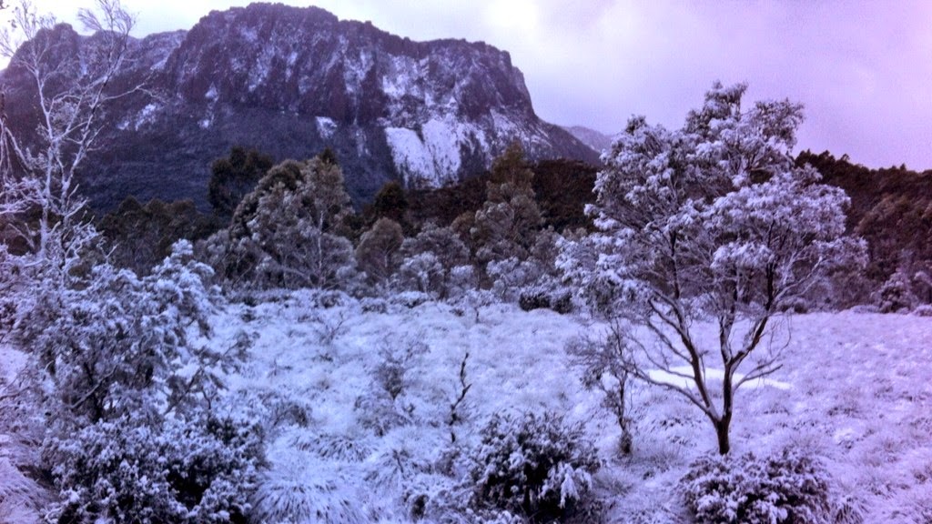
1. Overland Track, mid-winter

Fellow walker on Overland Track, mid-winter.

No contest for my favourite walk this year – the Overland Track in mid-winter. Yes, the Overland Track has been around for a long time, and I've done bits of it before, but never in winter with snow bucketing down for two days, and climbing up ice to reach the summit of Mt Ossa. For the first year ever, the wonderful Cradle Mountain Huts, now run by the Tasmanian Walking Company, were thrown open for a trial winter walk. It was an absolute cracker, and ended up being one of my best photo shoots ever (see story and images in Outback magazine), with frozen waterfalls, ice, sun, driving rain and snow. Despite the fact that we had to evacuate one of our party by helicopter on the second morning, the trip was deemed a roaring success, and it will now be offered next year. My advice, if you have never done the Overland Track, or even if you have, sign up for the experience. And not just for the warm stove and crackerjack meal that's cooked for you at the end of the day - the walking is stunning.

2. Marvelling at the Marbles

Round and round you walk.
Almost slap bang in the middle of the NT, the Devils Marbles, or Karlu Karlu, are both a sacred site, and a wonderful sight. There are a few pads weaving their way in and out of the giant red boulders, and you can easily wander around for an hour or two before sunset and at sunrise just watching the light play over the rounded forms. The adventurous can climb on top of some. A wonderful spot in the arid lands.


3. Kooljaman, Cape Leveque

Look at those colours! Kooljaman Wilderness Safari Camp.

The featured bright red cliffs towering over white sand at Kooljaman, north of Broome, WA, have been featured in zillions of photos, and rightly so. But on the other side of Kooljaman Wilderness Safari Camp, heading up the coast, a little sand track that winds past the solar farm passes one of the most amazing middens I've ever come across. Like I imagine most middens used to be, it is riddled not just with shells, but with stone tools used to open the shells. I wandered around it for quite some time amazed that such a special site so close to a resort has been (thankfully) left so untouched. Please, if you go there, do not take anything away from this special place. (Apologies, most of my photos from this trip have not been published yet so I can't put them in here.)

4. Scenic Rim Trail, southern Qld 

Climbing the cool mountains of Qld on the Scenic Rim Trail.

Another one for those who like walking, but also like a bit of luxury with it, this is a brand new three-night walking experience from Spicers. The walk, which is in the cooler mountains of Queensland, includes some energising uphills and some of the most beautiful ancient hoop pine forest I've ever seen, but the real highlight is staying both at Spicer's Canopy retreat, in sumptuous safari tents, and then at the luxurious Spicers Peak Lodge, where you are treated to a seven-course degustation dinner, spas and divine views.
And this is what awaits on the last night: Spicers Peak Lodge.

5. Walking around Mecca

Okay, I'm showing my bias here, and maybe non rock-climbers will question this. But it was such a joy to get to the Mecca of Australian rock-climbing, Mt Arapiles in western Victoria. This wonderful spot has thousands of climbs just a few minutes walk from the campsite, but it also offers extensive views and wildlife galore. There are walks around and up the mountain, and well worth dropping in there for a walk (but probably not in the heat of summer).
Mt Arapiles, showing The Pines campground in the background.


I'm definitely looking forward to a lot more exploring and walking in 2015, including, hopefully another new walk experience that hasn't received much publicity yet – the sail/walk Wineglass Bay trip put on by the Tasmanian Walking Company. Keep an eye out too for the new Three Capes Track, also in Tasmania, that will hopefully be finished in 2015.

See you on the track.
www.kensbigbackyard.com.au


Sunday 30 November 2014

Serendipity Canyon

Serendipity Canyon, Blue Mountains, NSW

A relatively short canyon, with a limited walk in and out and relatively easy navigation. However, the abseils are often tricky and not suitable for beginners.

Serendipity Canyon, Blue Mountains, NSW


Yesterday I had the pleasure of doing this canyon again. It had been quite a few years since I'd done it, and the water levels were quite different last time, so much of it felt completely different - like a whole new canyon!
Relatively easy, and one of the popular Wollangambe canyons, Serendipity starts and finishes near the fire station at Mt Wilson. Even with a group of 8 this time (yes, too big a group - canyon groups as a rule should be no more than 6), and a few relative novices in the sport of canyoning, we were back at the car five hours later, despite a long and luxurious lunch stop at a cracking great waterhole at the end of the canyon, and having an age range in our group of 14 to over 60. A smaller, more experienced group would usually do it much quicker, however you may find other groups in there which will slow your progress.
I think its alternate name, "Why don't we do it in the road", is because the walk in is comparatively short and easy.

The start
Abseiling in off the overhang start

You can park at the fire station, or at the campground a couple of kilometres further up the road, but this time we parked about 200m past the fire station (room for a couple of cars), which saved a bit of walking. You can walk straight down the fire trail here, turn right at the intersection, and then after a while turn left at the distinct exit track for Wollangambe one. Veer right after a while at the termite mound, and then right again to get to the start of the canyon.
The start of the canyon has two optional abseils from a tree across the creek. My recommendation is NOT to do these abseils, unless you really want the extra experience for less-experienced abseilers  in your group. The two abseils are time-consuming, unnecessary and don't really add anything.
Instead, I'd recommend not crossing the creek, but taking the winding track down to the start of the next abseil.
There are two possible abseil points here - one slightly easier one down the slope (the first you come to) or about 10m further on is an overhang abseil.

The middle
From here there is a fair bit of walking, wading, and pleasant creek walking through ferns and bracken until you get to the next abseil. This is where the canyon proper begins.
The start of the canyon proper. A slightly awkward beginning to the abseil.

This abseil has an awkward start and half way down may involve a bit of a swing. Helmets are recommended. But it's a beautiful slot, with the usual polished stone and other sculpted features.
There's a bit of a swim and a few scrambles then to the next abseils.
The second-last abseil is also quite tricky, with a nasty little slot that makes the start inconvenient, and again a slippery overhang that can be quite challenging to get everyone down without injury. We found it helpful to have an experienced canyoner at the top talking beginners down it.

The end
Unlike some canyons, it's quite obvious when you get to the end of Serendipity, making navigation relatively easy. You'll reach the Wollangambe River. You can either go all the way down to the river, or about 60m before it, head high along a ledge to the left. This small ledge may involve a bit of crawling along, which is quite inconvenient if you have a large pack, and a slip off the edge wouldn't be pretty. But it's an extra fun element that you don't get if you go right down to the river.
Either way, a couple of hundred metres to the left you'll see the exit track going up a steep ravine. Just below it, on the river, is a gorgeous flat-rock area, with an even better deep waterhole below it, perfect for jumping into and being refreshed before the walk out.
The end of Serendipity, with a jump rock off the lunch ledge.

An alternative (which I haven't done) if you want a much longer day out, is to take the Wollangambe River to the right, and complete all of Wollangambe 2 canyon. A flotation device is recommended for this.


Sunday 26 October 2014

How to cook kangaroo tail

How to cook kangaroo tail

This will probably be my shortest post ever, as it's pretty simple.

Where's my tail?

Out in the bush (i.e, west of the Divide), supermarkets often sell kangaroo tail. Big monsters of things, they're usually in the freezer section and are like a massive hairy club. They don't seem to make it to the city (certainly, I've never seen them), and I reckon it's because people in the bush know they're onto a good thing. Most kangaroo meat is very lean (so quite healthy for a red meat), but the tail is one of the few places that has a fair bit of fat, adding succulence and a rich flavour. Several times I've heard Aboriginal people describe it as "a meal in itself". It's messy and very tactile to eat, like chowing down on a crab (you'll need a good wash afterwards), but good fun and dead easy to cook on a campfire.

Method

First, take your tail (defrosted) and burn the hair off. This involves either chucking it on a fire for a minute or two, or somehow holding it over a fire and singeing it until black all over.
Then wrap it in alfoil. Wrap it well - one layer probably isn't enough. If you've cut the tail into sections, it'll look like a few garlic breads, or otherwise it'll be one lovely big silver present.

Then put it on the coals of the fire. Heap other coals over it.

After about 40 minutes, it should be done. I was recently told one of the best ways to check it is to stand on it, and if it is a bit squishy, it is done. If still hard, then put it back on. You can also try opening up a bit and seeing if the meat is cooked.

Then, let it cool a little (that fat will be quite hot) before attempting to wrestle with your meal.

Bon appetite.

Sunday 19 October 2014

Aileron Roadhouse

Aileron Roadhouse

A bit over an hour north of Alice, this dusty truckstop is about to have a makeover. Of sorts. Well, some grass, anyway.


Big Man Walk, Aileron Roadhouse

Picture Alice Springs on a map of Australia. If you're as geographically challenged as I didn't think I was, you'll probably put it much further south than it is. Even though I've been there several times before, I honestly hadn't realised how far north it is until I drove up the Stuart Highway. It's only about half an hour out of Alice that you cross the Tropic of Capricorn. Yes, that tropic – the line that runs through Rockhampton and cuts the west coast between Exmouth and Carnarvon.
Another 40 minutes or so up the road and you come to Aileron Roadhouse. In many ways it's barely distinguishable from any of the other roadhouses up this way – a dusty area to park your van or tent, a few rooms to rent, a bar (of course – this is the NT afterall), a general store, and some standard pub fare. Actually, the food is better than most (the roast chicken was a huge feast and quite delicious) and the rooms aren't bad, although mine needed some serious airing when I got there (it stank).
Big Blackfella, Aileron Roadhouse

But it has an incredible 17m high statue of an Anmatjere man, holding his spear, at the top of a hill behind the roadhouse. Costing about $120,000, the statue was built by Mark Egan and erected in 2005. There's a short little climb up the hill at the back (a leisurely 20 minutes return), which is worth it because it offers a great view over the surrounding plain. You'll also find out how big the AILERON letters are near the Big Blackfella, and see how impressive a figure he is.
In 2008, Mark added a huge woman and child, hunting goanna, down beside the roadhouse.
Woman and child hunting goanna

A working cattle station, Aileron has a couple of other great features that you can explore. From the top of the hill you can look over the old racetrack, built 1940s, or explore it via the bush tracks. It's still used for the Aileron Bush Weekend, held 4-5 April next year, which includes a rodeo. And if you haven't been to a bush rodeo yet, make sure you put it on your bucket list, as they are extraordinary spectacles.
Strangely, I felt like a run, so went out to the track and ran a few miles. I didn't whinny though.
Two other things happened during my brief overnight stay there earlier this month: the owner revealed that Aileron is getting a more secure water supply, which means they will endeavour to grow some grass to keep the dust down and some more plants to pretty the place up a little (although they've been warned by regulars not to change it too much); and photographer Heath Holden and I were lucky to witness the full lunar eclipse in those clear skies.
Blood moon and the Southern Cross, from Aileron Roadhouse

Through our camera lenses we played with the blood-orange moon and a windmill for a while, then walked up the hill and experimented with the statue looking at the eclipse. All good fun, but the best bit was putting away the cameras up that hill, pulling out a couple of cold XXXX, and just watching the eclipse beside the Big Blackfella, from his vantage point watching over the whole region.
Ahhh. That's NT bliss.


Sunday 12 October 2014

Camping at Devils Marbles

Camping at Devils Marbles (Karlu Karlu)

Not the best camp ground in the world, but the sunset and sunrise makes it worth sleeping at this magic spot.


Devils Marbles, just off the Stuart Highway, Northern Territory.

It's no wonder that brilliant Aussie landscape photographer Ken Duncan only refers to this classic  landmark as "God's Marbles". Pretty much in the middle of the Northern Territory, the marbles are a spectacular sight and combine so much of what we photographers love about our arid regions: brilliant red rock that gets redder at sunset and sunrise, a fairly harsh, flat landscape around it, and fantastic geometric shapes that are a photographer's dream.
It has a few Indigenous names, but the most commonly sprouted is Karlu Karlu. For a few years many of us were told that to the "Aboriginal people" (not sure which group) these large 1.6 billion-year-old granite formations were the Rainbow Serpent's eggs. No one I spoke to seems to know where this idea came from, and the Alyawarre people I interviewed recently referred to instead a vast Dreaming figure who wore a hair belt. The hair belt became dirty, and as he spun around, bits of mud and hair came flying off the belt to form Karlu Karlu.
Sunrise, Karlu Karlu

To the casual visitor, the site is "in the middle of nowhere". It's a decent drive of four hours from Alice, and an hour from Tennant Creek, so many people who are passing through tend to go there in the middle of the day. It's pretty much the worst time to be there. It's undoubtedly hot (with little shade anywhere) and the boulders themselves are at their colourless worst.
If you want to see them early morning and late evening, you can either stay at the Wauchope Hotel about 15 minutes drive down the road (nothing to rave about, but clean sheets and a telly), or you can camp.
Under an almost full moon

The campground is right at the Devils Marbles. I slept in a swag, and with an almost full moon, had a glorious, ever-changing view of the features all night. Great for star-trail photography etc, and just being in such a wonderful place. It's no effort to get up for sunrise and you don't need to drive anywhere - you can just pop out of bed and you are right in the area. There's plenty of opportunity then to walk around the huge area and look at many of the features as the sun plays its golden light over the surfaces, and the shadows gradually change.
The campground, however, has no water and very little shade. There are probably two campsites that have a decent tree, but the other 20 or so don't - so either get there early and grab the good sites, or expect to have no shade! Once again, there's no water (and if you are there during the middle of the day, you'll need some), but there are pit toilets. The one furthest away from the campsites (only about 100m away) is not surprisingly the least smelly.
There are little fireplaces at most of the campsites, but you'll need to bring your own firewood.
Overall, it was a pleasure to finally get to this spot of which I've seen so many photos  (and now have so many photos of my own). I'm really glad I camped there, to hang around for the sunset and sunrise, and fully recommend sleeping in a swag, which you can set up with your own personal view of the marbles, in the hotel of a thousand stars.
Sunset, Karlu Karlu


www.kensbigbackyard.com.au  

Saturday 6 September 2014

Top 5 Spring Walks in NSW

Top 5 Spring Walks in NSW

Season of snakes and small birds, spring in the NSW bush is rarely as spectacular as it can be in other parts of the world, but in some areas the bush tracks are festooned with flowers, and the amiable weather can suit short strolls or longer treks. It's a great time to be in the outdoors.

Here are five of my top recommendations for spring walking in this diverse state.

Waratahs aplenty near Pulpit Rock, Blue Mountains.

 1. Evans Lookout to Pulpit Rock, Blue Mountains
Virtually one continuous lookout along a spectacular clifftop, this 13km return walk provides stunning views of waterfalls, valleys, cliffs and one of the best opportunities to see NSW waratahs on a main track in the Blue Mountains. It undulates a little, but there are no large descents or ascents. The ending, Pulpit Rock, is surely one of the most underrated, dramatic features in the mountains. Access the walk via Evans Lookout Rd, Govetts Leap Rd or Pulpit Rock Rd.
The dramatic Pulpit Rock lookout.

2. Muogamarra Nature Reserve, Sydney
Usually only open for six weekends a year in spring, this wonderful refuge north of Hornsby has wildflowers galore (including NSW waratahs), Aboriginal engravings, lookouts and historic features. I've written a whole separate blog on this wonderful spot, which you can read here. If you're looking for something to do on a weekend in spring, I thoroughly recommend it.

3. Grand High Tops, Warrumbungles

Warrumbungle National Park. Amazing wildflowers in a dramatic volcanic landscape.
One of the most classic walks in NSW, through impressive volcanic country, this 16.5km loop walk was closed for some time after the devastatingly destructive fire of January 2013, but has recently reopened. Although the bush will take a long time to recover, there will be wildflowers out during the spring, and the views of features such as The Breadknife, Belougery Sprie, Crater Bluff and Bluff Mountains are some of the best in the state at any time of year.

4. Boomeri Camping Area to Shelley Beach Camping Area, Myall Lake

Best done as an overnight walk, this 25km return walk does involve a lot of slogging along a flat fire trail. But if you keep your eyes open, it will be a spring wonderland of wildflowers and wildlife, with birds galore, goannas, lizards, snakes and other surprises. The camping areas at Johnsons Beach and Shelley Beach are delightful, and worth hiking in for. Both on the shores of Myall Lake.

5. Light to Light Walk, Ben Boyd National Park

Ben Boyd National Park

I still believe this is the most spectacular coastline in NSW. It is right in the far south-east corner of the state, and this multi-day walk (probably best over 2 days) goes between two lighthouses, one of which you can stay in. The colours are extraordinary, from the orange and maroon rocks, to the turquoise and aqua water, and the wildlife is rich, with turtles, whales, wallabies, wombats and dolphins. It is relatively flat, easy walking, and there is a great camping area halfway, at Saltwater Creek. The worst thing is that the 32km walk currently has no organised transport to get back to the start, so you either need to do a long, long car shuffle, or walk both ways. Or you could just drive to Saltwater Creek, set up camp, and go for long day walks in each direction.

Full track notes and more information is provided on all these walks in my book, Top Walks in NSW. It's currently available for a bargain if you look around, and there's an e-version to download on your ipad.

See you on the track
www.kensbigbackyard.com.au

Sunday 24 August 2014

Latest Glam Multi-day Walks in Australia

Latest Glam Multi-day Walks in Australia

Comparing two of the latest guided multi-day walking experiences in Australia 

Scenic Rim Trail, southern Queensland

Looking for something more than a day walk, but not sure you want the hassles of carrying a large pack and tent? Want to finish a day's walk with a hot shower, comfy bed and a glass of wine, not a packet of two-minute noodles and a thin mattress on the ground?
Great Walks of Australia has a growing list of Australia's best multi-day walking experiences, but with strict criteria to get on their list: there must be private accommodation along the way, an emphasis on quality food and wine, and walks must be guided by knowledgeable guides.
I've walked parts of nearly all the walks listed by Great Walks of Australia, and this year, through my work for various publications, I was blessed to enjoy two of the latest walking experiences on offer in the great walks group. Here's a little compare and contrast, in case you were considering either. Please note both trips were provided gratis to me.

Scenic Rim Trail
This is the newest and cheapest of the Great Walks of Australia - but don't be fooled into thinking this is a shonky operation. Established by the classy Spicer's brand, the highlight here is definitely the food and the accommodation. Much of the walk is on the company's own beef farm in south-east Queensland, wandering through forests, woodlands and up mountains, occasionally dipping into national park. There are some great views to be had, and some lovely ancient hoop pine forest. It's pleasant, but for the most part, the walking isn't what you'd call spectacular. It's at the other end of the Scenic Rim to the renowned Lamington National Park, which for my money offers more beautiful terrain in this part of the country.
The mid-year season means that the weather on this three-night trip will almost always be pleasant too, with cool, crisp mornings (surprisingly cool for Queensland because of the relatively high altitude) and dry and warm days. The walking days are not too strenuous, although the uphill hikes will certainly make you feel like you are justified in having an extra glass or three of something at the end of the day. You don't have to carry any gear, apart from a camera, water and lunch, so the walking is wonderfully free and invigorating.
View from my plush bed at sunrise at Spicers Canopy.

The first two nights of the experience are spent at the exclusive Spicers Canopy glamping tents. These large, safari-tents have huge comfy beds in them, lounges and luxurious bath robes. You can leave the canopy doors wide open and watch the stars from the comfort of your huge bed, or seal everything up. Food and wine are divine, and only superseded by the final night, when you stay at the luxurious five-star Spicer's Peak Lodge, the highest lodge in Queensland, and are treated to a sumptuous seven-course degustation dinner, with matching wines. It's an extraordinary way to finish the trip, and certainly worth walking up a couple of mountains.
Spicers Peak Lodge. Ahhh.


Overland Track – in winter!
Since 1987, Cradle Mountain Huts has been guiding people 65km along the iconic Overland Track in the Central Highlands of Tasmania, past the craggy shape of Cradle Mountain, over passes and through sodden valleys all the way to Lake St Clair. It can be super wet, super cold, super muddy and some people have done the whole trip without ever seeing a mountain because they were shrouded in thick mist and rain the whole time.
View from Cradle Mountain Hut of Cathedral Mountain after heavy snowfall.

For the first time ever, Cradle Mountain Huts decided to trial a winter experience this year. Allowing an extra night (so now six nights), it wanted to see if guests were keen to see this gorgeous part of the world when it is at its coldest. And stunning it was. The rivers were thundering, the snow was thick and soft and deep in places, and the forests with snow in them were a fairy land. I can't show you many photos, because my story in OUTBACK magazine is still to come out (keep an eye out for the Oct/Nov issue), but sufficient to say it is probably the most beautiful long-distance bushwalk I have ever been on. We had wind that knocked us over, rain that soaked us, and snow that filled our packs, but it was worth it.
Top of Pelion East in winter.

This is not a walk for non-walkers. Some days were taxing, and because there is no other access to the huts, you need to carry a reasonable load (at least 15kg), including snow shoes, crampons and emergency sleeping gear. But at the end of each day, you get to the secluded and private Cradle Mountains Hut, to have hot showers, a glass or two of wine, and a delicious and nutritious hot meal cooked by your guides. There is certainly no degustation menu, but the food is plentiful and surprisingly good, with three or four courses every night. The huts are welcoming, but it is not five-star. The bedrooms were iceboxes, and you need the warm sleeping bags provided.

Overall, the experiences couldn't really be more different: one is perfect for casual walkers who want a different experience and to enjoy some top-class food and accommodation; the other is an incredible walking experience, with the comfort and safety of guides and huts, but in the wilds of a Tasmanian winter and whatever it decides to dish out.
Or to put it another way, one is perfect for my wife, the other perfect for me.

See you on the track
www.kensbigbackyard.com.au

Saturday 2 August 2014

How outdoor shops are stopping people going outdoors

Outdoor shops stopping people going outdoors

Our capitalistic, narcissistic obsession with "stuff" is making it too expensive and too damn hard to go bush.

An amazing camping experience, without all the latest "essential" gear: North West Island, Queensland.


Back in the Middle Ages, when I was studying at the University of Technology, Sydney, advertising 101 included the basic aim of advertising in a capitalist economy: to sell people stuff they don't need. It's pretty simple really – if people actually need things, they either have them already, or know how and where to get them (and are simply prevented by circumstances such as finances). So advertising's only purpose is to convince people that they actually need more than they currently have, in order that they will buy stuff and keep this strange, environment-destroying economy going. Economic growth is purported to be the ultimate good, and the sign of a "strong" politically adept society, as opposed to a malfunctioning catastrophe that is continuing to plunder resources to create things we don't actually need.
Been to an outdoor/camping shop lately? Seen the extraordinary range of goods on offer? I'm talking about Kathmandu, Mountain Designs, Paddy Pallin, etc, etc. The range is bewildering at best, and the prices, in many cases, extraordinary.
My elder sister (now the high side of 50) received a Duke of Edinburgh award when she was at school. She had a simple, two-pole A-frame hike tent that I was still using 20 years later, a fairly crappy, heavy sleeping bag, and a rough, framed pack. My folks weren't rich, but could afford all of that, and encouraged her to go, despite her tiny size and lack of experience.
Today, I hear of parents not allowing their kids to do the excellent Duke of Edinburgh program, because it simply costs too much. By the time the kids buy all the gear, and pay for the increasingly heinous and compulsory costs for the school to employ an outside company to run the program (in most cases now, it's not considered acceptable for a teacher with great camping/hiking experience to run the course), the cost can be well over $1000. This is just for kids to get out in the bush and go for a walk for a couple of days. I think it is obscene.
My encouragement in my book, Top Walks in NSW, and in fact whenever I get the chance, is to just get out in the bush with a few simple things, and down the track work out if you'd like to upgrade something.
Start simple, and add things as you feel you need them.

If you are not doing something extreme (such as off-track camping in the high country in winter), and take a few simple precautions, you really don't need a lot of "stuff" and you don't need to spend hideous amounts of money, despite what the outdoor shops will tell you. Yes, you need something on your feet. If the track you're planning isn't particularly stony, try your sneakers if you have nothing better. Heck, the old Dunlop Volleys was used to set some of the most classic rock climbs in the Blue Mountains.
Yes, you need a pack to carry stuff in, but I wouldn't recommend spending hundreds of dollars until you know what you want. My wife just bought a $40, 65-litre pack from Aldi for my son. I loaded it up with some heavy weights and took it for a field test . It has pockets in the right places, a rain cover, padded hip straps, and certainly on a three-hour walk was as comfy as my $250 pack. I don't expect it to last as long, or to be as good in all conditions, but heck, maybe that's all you need. And why spend $250 or more on a pack if you use it once every two years?
A $40, 65-litre Aldi backpack. No worries.

You will need a raincoat, but I find little difference between $70 raincoats and $300 raincoats. I get slightly damp (but not wet) in both. You will need something to cook on, and something to sleep in, but you may not need to get the most recent ultra-light, Himalayan standard sleeping bag if you are just going car camping a couple of times a year. In fact, if that's the case you may not even need a bag at all - often a doona and sheets will be more comfortable anyway.
Some of the staff in outdoor stores are incredibly knowledgeable and keen hikers/climbers/canyoners/campers themselves. Their advice can be invaluable. But just don't get sucked in to thinking that you need the latest and greatest thing in order to get out in the bush. You don't.
I'm about to hit the Overland Track mid-winter, during a predicted fierce cold snap, with snow down to 200m. I'll be interested to see how my conglomeration of assorted gear from various previous outdoor sports over the years (skiing, canyoning, hiking etc) stands up to the challenge. The only thing I bought new was $40 gaiters, as I've never previously had the need to buy them, although I did once borrow a friend's pair of gaiters for hiking through spinifex in the Kimberley.

Hope to see you out there sometime.
www.kensbigbackyard.com.au

Saturday 19 July 2014

Red Hands Cave walk

Red Hands Cave walk

One of the closest Blue Mountains walks to Sydney is a cultural spectacle through a bird-filled valley.

Red Hands Cave, showing hand prints and hand stencils in different ochres.

I've mentioned before that one of the difficulties for those of us who bushwalk regularly is that we have  favourite walks and favourite areas to walk, and it can become hard to make the time to try other areas. When I do get a half or full day to go hiking, I want to go somewhere that I know I'll love, rather than just somewhere ho-hum.
As a result, when I'm driving up the Blue Mountains from Sydney, I nearly always drive past the Glenbrook entrance to Blue Mountains National Park, which holds just about the closest Blue Mountains walks to Sydney. In fact on a Sunday morn, it's less than an hour's drive from my place in suburban Ryde. You basically drive up the steep escarpment and Glenbrook is the first little village. The only times I've really hung around this area are because it's the end of the legendary Oaks Fire Trail mountain bike ride, or because of the extensive camping and picnicking areas at Euroka Clearing, where wallabies and kangaroos are fairly easily spotted at dusk.
Many times I've driven past, knowing that a walk I would do "one day" would be the little walk to Red Hands Cave, an Aboriginal site. I've seen lots of handprints and hand stencils on walls before, so I guess it hasn't been high on my priority list.
But today I finally got there, and it's a little gem of a walk. If you start down at the delightful Jellybean Pool (perfect for a swim in summer) it's basically a P shape walk, with a loop at the far end. It weighs in at about 8km, and 11-year-old legs today did it in an easygoing 3 hours, with a few breaks.

Start

You can park at the top ranger station, or I think it's better to drive to the Jellybean Pool carpark (in summer this might be crowded). Wander down the stairs to the pool, then turn sharply right and scramble up and over track along the creek to the right. After about 5 minutes, you'll hit the road. Cross the causeway, then turn right along the marked track.
Across the causeway, Blue Mountains National Park, Glenbrook.

This takes you up a lovely bird-filled valley. Without trying, we saw whipbirds, gang-gang cockatoos, king parrots, golden whistlers and fairy wrens. There are some lovely large overhangs to check out and some gorgeous mixed trees in the forest, including the pink smooth-barked apples. A bit over half an hour of walking will bring you to the loop track.
Red Hands Cave Walking Track.

Red Hands Cave

I think the loop is best done anti-clockwise (because of the steep stairs on the loop track), so continue straight ahead, and the walk gradually climbs up the valley. Then all of a sudden you'll be at the sensational Red Hands Cave. Unlike many sites, it has both hand stencils (outlines of hands) and hand prints, and the dozens of images are starkly clear. It of course has a large mesh barrier around it, but even that doesn't take away from the magnificence of this site. Handprints have been estimated at up to 1600 years old, and there are a few other drawings too. On the floor of the cave you can clearly see the ochre grinding grooves, some stone tools, and a pile of red ochre.

The loop 

Once you've enjoyed this special spot, continue up the path, and in about 10 minutes you'll hit the car park and picnic area, which has a pit toilet. A track leads from the picnic area (not marked), which is the loop track. It seemingly heads off in the wrong direction for a while, but does make it back, via a different, lovely valley. Half an hour's walk down this track will take you to a small rock clearing on the creek on the left hand side. Stop here, as it has some very well defined and picturesque axe-grinding grooves. Stay for a while and see what else you notice, as there are other less-defined features. It's a good spot for a break.
Clearly defined grinding grooves and other features.

Back for a swim

The main track continues about another 5-10 minutes before it rejoins the original track, and you simply turn right, and follow it back to Jellybean Pool and that waiting swim. It's pretty brisk in winter, so you can almost guarantee you'll have it to yourself.
Overall, it's a corker of a little walk, and I really felt privileged to see two such well-preserved Indigenous sites so close to Sydney.
www.kensbigbackyard.com.au

Saturday 12 July 2014

Best bushwalks in each state in Australia

Best bushwalks in each state in Australia

Well, here are my personal favourites anyway. Would love to hear about yours!


This time of year remains one of the best times to get out and about, and our country has such a wealth of wonderful tracks on which to lose yourself for a couple of hours, or a couple of days. I've been blessed to have walked in every state in the country, and although there are still many, many more tracks to explore, here are my current favourites. (Although the great thing about any list of 'favourites' is that it can change.)

ACT

With everything from snow-capped mountains covered in alpine vegetation, to wetlands, the ACT has a lot to offer the keen bushwalker. My favourite walk though is a fun little gem, found in my book Top Walks in NSW. It's called Square Rock, and finishes with a short climb up a ladder to an extraordinary 3D rock playground on the edge of a precipice. Views, wildlife and a bit of an adventure - all in a few hours. 9km return. Definitely recommended.
Square Rock, ACT


NSW

Admittedly I've done much more walking in my home state than any other, and so I have a much wider choice. My top 63 walks are in Top Walks in NSW. But my absolute favourite walk in the state remains the century-old National Pass. With dramatic cliffs, sensational views, plunging waterfalls, rainforest and NSW's only endemic bird species, it's a brilliant walk at any time of year, and in any weather. Allow half a day for the steep 6km loop.
The wonderfully precipitous path on the National Pass, Blue Mountains.


NT

So many great walks to choose from, from desert country to tropics, and my pick of the bunch is a little walk that few do. I haven't done it for a few years now, so I hope it is still as good, but my memories of doing it with my parents, a child in a backpack on my back, and a pregnant wife, are very vivid. It's called Chain of Ponds, is a 3.5km loop, and is in Trephina GorgeNature Park. Trephina Gorge itself is worth wandering up too - all within the less-visited East MacDonnell Ranges.

QLD

A couple of weeks ago I returned from the only "great walk" in Queensland, the new four-day Scenic Rim Trail. I do love those highlands in the south-east part of Queensland, and my favourite walk is actually on the other end of the Scenic Rim, in Lamington National Park. It's the 17km Tooloona Creek circuit, leaving from O'Reilly's, or the walk through to Binna Burra,  via Tooloona Creek rather than just the Border Track. There are Antarctic beech trees, gorgeous rainforest, and birds galore. A solid day out for those not used to walking, but a joy nonetheless.

SA

I must admit my walking experiences in SA are limited, and I am still hoping to get to that bushwalking mecca of the Flinders Ranges. I've had some great experiences though on Kangaroo Island. But my favourite walk is way up in the north-east corner of the state, along Cullyamurra Waterhole near Innamincka. Wonderful outback scenery, birds such as brolgas and the sad history of Burke and Wills. At the top of the waterhole are some extensive Aboriginal engravings. Camp along the waterhole and just explore as far as you want.

TAS

Oh, again, so, many walks from which to choose, and I've been blessed to have experienced so many. Cradle-Mountain-Lake St Clair National Park is a favourite area to hike (how good are the Twisted Lakes?), as is Mount Field National Park. One of the most popular tourist sites in the country is the Tahune Airwalk on the Huon River, a raised platform walk on forestry land, 90 minutes drive south of Hobart. Just near it, however, is Hartz Mountains National Park, an untamed sub-alpine wilderness, with swirling winds, changing moods, and, if you hit it on the right day, some of the best views over Tasmania's south-west forests. Few people go here, and you will need to be well prepared, but the five-hour walk up Hartz Peak is an absolute cracker.

The track less-travelled: Hartz Mountains National Park, Tas.


VIC

From alpine areas to wild coastline and wonderful koala-filled forests along the Great Ocean Walk, as well as one of my favourite national parks in the country, the Grampians, Victoria has been known for many years as the best state for bushwalking in the country. My favourite walk is the multi-day 35km  loop to Sealers Cove and Refuge Cove in Wilsons Promontory National Park. Gorgeous remote beaches, wildlife including wombats, and some of the nicest coastal scenery in the country. It's no wonder this is such a popular national park for Victorians.

WA

Again, what a wealth of riches in this vast state, from the subalpine peaks of the Stirling Range National Park (again, one of my favourite national parks in the country), to the towering karri, marri and jarrah forests, to the floral bonanza of Fitzgerald River National Park. But I'm going to jump to a walk way up in the Kimberley, in Purnululu National Park. The multi-day walk up Piccaninny Creek, past one of the most beautiful and iconic landforms in Australia - the extraordinary Bungle Bungles - this walk will probably see you wading through waterholes, avoiding wildlife such as snakes, and dodging prickly spinifex. It's the only gorge within the park that you are allowed to explore, and I've met people up there camping for nine days. But even a hike one day in, then setting up a camp and exploring from there, will see you deeply immersed in one of the most spectacular parts of the country.

As always, I'm keen to hear from others - particularly so I can keep a lookout for my next walks.
www.kensbigbackyard.com.au      

Sunday 6 July 2014

We need higher taxes

We need higher taxes

Yeah, that's right. Charge me more for being an Aussie worker.

Go on. Tax me harder.

At this time of the financial year, when we dread getting out the magic shoebox of receipts and wading through spreadsheets in order to come up with paying the least tax we can get away with, I want to sit back and reflect about a few things.

Today we had the "bust the budget" marches across Sydney, Melbourne and elsewhere complaining (quite rightfully) about the current financial slashing of a whole host of things that were previously considered important in this country: the environment, science, the arts, conservation, tertiary education, health, elderly care, foreign aid ... to name a few.
Now, like everyone, if I was in power, I would prefer to see financial slashing of other parts of the budget. For example, defence always seems to get a big swag of cash that is sacrosanct. But I am not making those decisions, and don't know all the pre-existing agreements and ins and outs of dropping spending on something, just because it isn't the bees knees in my way of thinking. Yes, I would make different decisions, but so would everyone.
So, in the light of that, it becomes increasingly clear that our governments just need more cash. I want government to spend money on protecting biodiversity. I want it to fulfil its international obligations on asylum seekers, on foreign aid, on creating new protected areas. I want it to properly fund our health,  education and science sectors, so that we can again be world-leading innovators and changers. I want a thriving arts community. I want a public transport system that works well, and is integrated, and forward thinking. I want more development of green power and farming methods that will see us prosper and look after our land for unlimited generations to come.
Politicians of any political persuasion won't pitch as their election promise "I promise to raise taxes" – hardly slides down the throat with a nice shiraz. But perhaps my little voice can be added to a few others to say, "hey, tax us a little more, and then deliver us what we really want".

www.kensbigbackyard.com

Saturday 21 June 2014

Easy rock climbs around Sydney

Easy rock climbs around Sydney

Some recommended outdoor rock climbs for beginners or those with creaky knees

Ken Eastwood feeling "Hope" (grade 15), Mt Piddington.

I get such a buzz out of rock-climbing. Particularly lead-climbing. There are very few other moments in life when I am completely "in the moment", focused totally on every move, on every dimple in the rock, on the kiss of the sun on my skin or the breeze at my back.
I also love sharing the joy of rock-climbing, and end up taking out a lot of people new to the sport, or those who want to get out of the climbing gym and try the outdoors.
I suspect there are many people in and around Sydney who have struggled, as I have, to find great areas to take beginners. Also, the reality is that as approach a half century, and don't spend nearly enough time on rock, that I will increasingly need to find easier spots to climb myself.
Unlike some other cities, we don't have that many superb, easy places to climb. Brisbane is so well set up with Kangaroo Point. It's lit up at night, so you can climb in the evenings, and has excellent fixed protection at the top so it is easy to set up top ropes.
After almost 20 years of outdoor climbing, I reckon good areas for beginners (or those who want an easy day out at the rock) have reasonably easy top-rope set ups, aren't overly steep (not past the vertical), and have at least some holds with big, chunky holds, so that everyone can get up at least one climb. These are surprisingly hard to come by.
Once climbers have experience, particularly in lead-climbing with a natural protection rack, the Blue Mountains becomes an obvious choice, because there are just so many climbs up there, and hundreds upon hundreds at easier grades – some of which are superb adventures. Heck, the very first climb in the brilliant guidebook Blue Mountains Climbing is a superb four-star, 150m epic called Tom Thumb, at a very achievable grade 13. However, I think it is ridiculous to think that beginners with no experience would or should attempt that. Some time needs to be spent learning a few techniques and moves, and getting comfortable on rock first.
So, the following isn't by any means an extensive list (and favours the north side), but it shows some of the spots I have enjoyed fairly stress-free times out at a cliff. Please let me know your faves too, and I hope to see you out there sometime.

Lindfield Rocks

A classic bouldering area (meaning an area usually climbed without ropes), this can work quite well for beginners, particularly kids. It's relatively easy to set up top ropes, and if you choose your climbs carefully, most beginners should be able to get up a couple of routes. One of the problems with it as a bouldering area, is that it is high enough to be quite dangerous if you fall, and some of the landings are awful. However, it isn't really high enough for most climbers to be on rope (climbs are only about 6-8m long at best), but certainly works as a beginners spot. (Park at tennis courts at Lindfield Oval, and take the walking track for about 5 mins.)

Barrenjoey

The stupendous view over the isthmus, halfway up a climb at Barrenjoey.

Probably not for absolute beginners, but this is such an absolutely classic, gorgeous spot that it is definitely worth the drive up to Palm Beach. Hike along the bayside beach then bash along the bush for a few minutes and up to the cliffs. One of the best areas for beginners is the first area you come to on the south-west side, and you can spend a fun day poking around on climbs such as Millie, Carrie Bradshaw, Starboard Barnacles, Professor Wigginsworth's Chunder Bucket and Crack of Dawn. The views back along the isthmus are glorious. It will greatly help if someone in the group is confident leading sport climbs at grade 14, in order to get to the top. Afterwards, you get to swim at one of Sydney's best beaches, and can even do some easy and fun bouldering on the sand at the big boulders half way along the beach. 

Berowra

A little higher than the previous two spots, this can be a bit of a struggle for beginners, as grade 16 or 17 is often too hard for them. But there are lots and lots of climbs, you can set up top ropes fairly easily and if people are willing to have a go, you can still have a great day out here. It's also lovely and warm on winter arvos! Kenneth's climb (no, not named after me unfortunately, but after a lovely skink that used to live in the crack) is a challenging grade 14. Drive to the end of Wideview Road in Berowra, head left to the cliff and don't fall off.

The Stables

Hidden up in Pennant Hills, this is a surprisingly good little area in some lovely forest. Good for summer, as it's quite shady and protected. Best recommendations are getting to Storm Wall and doing climbs such as Clipz, Yoink, and Carrots are Vegetables if you're up to some jamming. Find it at the end of Schofield Parade, Pennant Hills and then follow the instructions in the online guide.

Suicide slabs (now called Brooklyn)

A bit of a run-out lead, so take care, but this big slab is in a glorious spot beside the boat ramp at Brooklyn. Exhibitionists will like it, as you usually get a bit of an audience. There's a two-star grade 15, and a couple of 14s, but easy to slide across and try a couple of slightly harder ones on top rope.

The Block, Medlow Bath

If you're up to heading into the Blue Mountains, it can be difficult to know where to start. So many gorgeous areas and climbs. This is a wonderful little spot, and if you study the guidebook and wander around a bit, you can find a host of climbs here. One of my regular climbing partners did her first lead climb here, a 22m long ripper called Manana, with a difficult finish. It's just around the corner from The Block, which has a mix of roots including the very nice line of Ole Biscuit Barrel (grade 14).

Mount Piddington, Mt Victoria

Top of Mt Piddington - glorious views.
With more than 200 routes here, there is plenty to keep you occupied at virtually any level of climbing. The bulk of it requires natural protection though, so not so great for those without access to a natural protection rig (placing cams, nuts, hexes and wires to protect you from a fall, rather than relying on pre-drilled bolts placed by someone else). Still, it's probably one of the best places around Sydney to learn to lead on a natural protection, because there are so many lower-grade climbs. The great unwashed, at Grade 10, is a fun, unusual climb with a great mix of moves. I had a bit of an epic recently on Chicken Hearted (grade 13), and have enjoyed playing on climbs such as Faith (an excellent three-star grade 8 with the ability to set up top ropes on chains to tackle some of the surrounding climbs), Hope, Chastity and Sincerity. Always scope here to take a break and admire the climbers attacking harder leads such as the five-star classic The Eternity (grade 18).

Please remember that climbing, like all outdoor sports, has inherent risks, and if you do not know what you are doing, you should join a club, befriend someone experienced, or pay for some training. Having said that, I maintain that statistically you are far more likely to get injured or killed driving or cycling to a climbing site or crossing the road than you are actually at the site.

Do you have other recommended areas that are great for beginners in and around Sydney? Please let me know!
www.kensbigbackyard.com.au

Saturday 14 June 2014

Australia's World Heritage Areas

Australia's World Heritage Areas

What is the purpose of the World Heritage list? What are the 18 Australian entries on the list?

The brand new Scenic Rim Trail, in the Gondwana Rainforests World Heritage Area.

I'm often surprised when I mention to people from the USA about World Heritage Listing (e.g, of an area such as the Blue Mountains) that most seem to have no idea what I am talking about. I'm even more perplexed when we have a government that is trying to de-list some Australian areas from the World Heritage list, as if it is something terrible that we should revoke.

Set up from 1972 by UNESCO, one of the arms of the United Nations, the World Heritage list was initially designed to prioritise which areas of the world we wanted preserved for evermore. The original list was of 12 places (a list first released in 1978) that were in great danger.
Three years later, the first Australian places were added to the list - the Great Barrier Reef, Willandra Lakes Region (home to Australia's oldest human remains) and Kakadu National Park.
Australia now has 18 entries on the list, including such diverse things as the Sydney Opera House and  Fossil Mammal sites at Riversleigh (Qld) and Naracoorte (SA). Some of our entries, such as the fossil sites, and the convict sites, are made up of multiple places in different locations. Others are large swathes of areas that are made up of different types of land use - national park, state land and private land.
As a science, environmental and outdoor-focused journalist, I've had the pleasure of visiting many of Australia's World Heritage-listed places. In fact, just last week I was hiking in part of the Gondwana Rainforests of Australia, a large area around the NSW/Qld border that is listed.
I will nearly always mention World Heritage listing in an article about those places and the people associated with them, because I think making this UNESCO list means that it has been recognised by a worldwide body as a very important place - something worth preserving. Some of the areas are listed for their cultural heritage, others for their exceptional natural beauty, because they clearly show certain progressions in the earth's development, or because they are preserving something – plants, animals, ecosystems, a cultural practice – in serious peril of being lost.
I do find it hard sometimes to look at our list and justify everything on it on a world standard. For example, do we really think that the Royal Exhibition Building and Carlton Gardens, in Melbourne, should stand on an equal world footing as the great pyramids of Egypt or the Great Wall of China? However, we do know that the Royal Exhibition Building is the world's only surviving example of a great hall from a major international 19th-century exhibition. Neither I – nor you, I suspect – have sat on the committee determining what does and doesn't make the list, and so to an extent I believe we need to honour their decisions (although of course they can be questioned and their criteria should always be up for review).
To have something put on the list is indeed an honour for a country, and shows some of the valuable things that the rest of the world feels need to be preserved, and I thought that politicians of all persuasions would accept and nurture that fact. Usually politicians are in agreement on listings.
Much research has shown that World Heritage listing can be of exceptional economic value to an area. In the Wet Tropics of far north Queensland, when logging was halted due to World Heritage listing, tourism rose exponentially in the area, and within two years was worth seven times as much as the logging industry had been. The Adelaide Hills area is well aware of this value, and is therefore currently pushing for World Heritage listing.
Of course, being on the list doesn't really ensure absolute protection, as the current campaign on "saving the Great Barrier Reef" shows. However, it does provide a firm basis for determining policy, and a commitment from the rest of the world to help with advice and support.
I'm stoked that I live in a country with 18 listings on the World Heritage register. How fantastic that we have so much worth preserving, and more people pushing for even more to be listed (current talk includes Cape York, the Great Forests of Victoria and Adelaide Hills).

In terms of the rest of the world, it is hard to make a comparison, but Canada is an obvious choice because it is vaguely similar in size, the population is within the same ballpark (34 million vs 24 million), and our economies are similar. Canada has 17 World Heritage listings, and we have 18. So we are certainly not out of kilter with that comparison.
I hope that we can use the World Heritage register to rejoice over what is deemed by the rest of the world to be important, and to celebrate with them the wonderful things that make up Australia.
Tasmanian Wilderness, Cradle Mountain-Lake St Clair National Park

Australia's World Heritage list

Great Barrier Reef
Kakadu National Park
Willandra Lakes Region
Sydney Opera House
Royal Exhibition Building and Carlton Gardens (Melbourne)
Gondwana Rainforests of Australia
Wet Tropics of Queensland
Australian Fossil Mammal sites (Riversleigh/Naracoorte)
Convict sites (11 locations)
Uluru-Kata Tjuta National Park
Greater Blue Mountains
Fraser Island
Tasmanian Wilderness
Purnululu National Park (Bungle Bungles)
Lord Howe Island group
Shark Bay
Heard and McDonald islands  
Macquarie Island